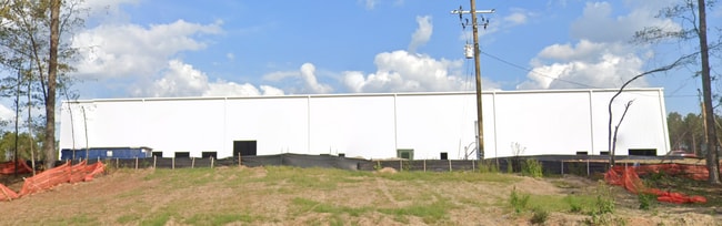
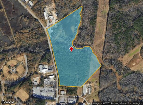
Property Record
890 Newton Bridge Rd, Athens, GA 30607
NEARBY LISTINGS FOR SALE OR LEASE
Property Detail
890 Newton Bridge Rd
104-003
Com-Ma-015->025-050
Coldstorage
DEEDED ACS: 38.000
AE
Clarke
13059C0006E
Georgia
0
37 AC
2025
North Athens
130300
Other Market Areas
62,856 SF
Athens-Clarke County, GA
DEMOGRAPHICS near 890 Newton Bridge Rd
1 Mile
3 Mile
5 Mile
2024 Total Population
2,396
23,361
81,511
2029 Population
2,392
23,486
82,496
Pop Growth 2024-2029
(0.17%)
+ 0.54%
+ 1.21%
Average Age
36
36
34
2024 Total Households
789
9,156
30,854
HH Growth 2024-2029
(0.13%)
+ 0.49%
+ 1.15%
Median Household Inc
$47,412
$49,188
$46,700
Avg Household Size
2.80
2.40
2.30
2024 Avg HH Vehicles
2.00
2.00
2.00
Median Home Value
$215,600
$223,366
$247,332
Median Year Built
1986
1985
1983
Nearby Places
Map Layers
Map Styles
 Street
 Aerial
- Restaurants
- Banks
- Shops
- Fitness
- Groceries
Nearby Properties
Address
Land Use
TOTAL SIZE
Lot Size
Zoning
Address
Land Use
TOTAL SIZE
Lot Size
Zoning
11.36 AC
G
Address
Land Use
TOTAL SIZE
Lot Size
Zoning
85,608 SF
63.75 AC
RM-2
Address
Land Use
TOTAL SIZE
Lot Size
Zoning
56.15 AC
G
Address
Land Use
TOTAL SIZE
Lot Size
Zoning
112,071 SF
5.27 AC
E-O
Address
Land Use
TOTAL SIZE
Lot Size
Zoning
8,357 SF
22.38 AC
RM-2
Address
Land Use
TOTAL SIZE
Lot Size
Zoning
77,919 SF
8 AC
E-I
Address
Land Use
TOTAL SIZE
Lot Size
Zoning
9,956 SF
7.20 AC
E-O(PD)
Address
Land Use
TOTAL SIZE
Lot Size
Zoning
58,706 SF
12.86 AC
C-G
Address
Land Use
TOTAL SIZE
Lot Size
Zoning
20.74 AC
G
Address
Land Use
TOTAL SIZE
Lot Size
Zoning
72,072 SF
7.59 AC
RM-2
Address
Land Use
TOTAL SIZE
Lot Size
Zoning
19.21 AC
G
Address
Land Use
TOTAL SIZE
Lot Size
Zoning
664,513 SF
84.46 AC
I
Address
Land Use
TOTAL SIZE
Lot Size
Zoning
106,760 SF
10.38 AC
E-O
Address
Land Use
TOTAL SIZE
Lot Size
Zoning
8.27 AC
G
Address
Land Use
TOTAL SIZE
Lot Size
Zoning
1.25 AC
G
Address
Land Use
TOTAL SIZE
Lot Size
Zoning
39.94 AC
C-O
Address
Land Use
TOTAL SIZE
Lot Size
Zoning
136,460 SF
13.27 AC
C-G
Address
Land Use
TOTAL SIZE
Lot Size
Zoning
33,669 SF
1.32 AC
C-N
Address
Land Use
TOTAL SIZE
Lot Size
Zoning
121,382 SF
16.01 AC
C-G
Address
Land Use
TOTAL SIZE
Lot Size
Zoning
15.34 AC
G
Address
Land Use
TOTAL SIZE
Lot Size
Zoning
31,067 SF
5.05 AC
C-O
Address
Land Use
TOTAL SIZE
Lot Size
Zoning
2,187 SF
46.64 AC
RM-1
Address
Land Use
TOTAL SIZE
Lot Size
Zoning
1,378 SF
21.13 AC
RM-1
Address
Land Use
TOTAL SIZE
Lot Size
Zoning
1.78 AC
G
Address
Land Use
TOTAL SIZE
Lot Size
Zoning
36,878 SF
1.33 AC
C-N
Address
Land Use
TOTAL SIZE
Lot Size
Zoning
1,568 SF
5.25 AC
RM-2
Address
Land Use
TOTAL SIZE
Lot Size
Zoning
3,052 SF
15.59 AC
C-G
Address
Land Use
TOTAL SIZE
Lot Size
Zoning
5.25 AC
C-D(ND)
Address
Land Use
TOTAL SIZE
Lot Size
Zoning
42,548 SF
5.34 AC
C-O
The World's #1 Commercial Real Estate Marketplace
Connect with us
© 2025 CoStar Group
The information above has been obtained from sources believed reliable. While we do not doubt its accuracy we have not verified it and make no guarantee, warranty or representation about it. It is your responsibility to independently confirm its accuracy and completeness. Any projections, opinions, assumptions, or estimates used are for example only and do not represent the current or future performance of the property. The value of this transaction to you depends on tax and other factors which should be evaluated by your tax, financial, and legal advisors. You and your advisors should conduct a careful, independent investigation of the property to determine to your satisfaction the suitability of the property for your needs.